
The Bardenas Reales Firing Range: A Restricted Zone with Centuries of Deeds
An aerial firing range inside a Biosphere Reserve, on communal land of medieval origin, with published restricted airspace and coordinates for anyone who cares to look.
The Bardenas Reales are a semi-desert of about 42,000 hectares in southeast Navarre, a Natural Park since 1999 and a Biosphere Reserve since 2000, whose communal ownership belongs to some twenty congozante entities with rights of medieval origin. Since the early 1950s an aerial firing range has operated there, established by agreement with that community and used by the Spanish Air Force (Ejército del Aire) and by allied forces. The airspace over the zone is restricted and published. Its night activity explains a good part of the sightings reported in the district.
Executive summary of the case file. Everything essential before you dig deeper.
Fact sheet
OSINT - Traceability
Some landscapes sound like countryside and some sound like a military bulletin. The Bardenas Reales sound like both, depending on the hour. In the early morning, in September, it smells of dry thyme and dust, you can hear the bells of a flock coming down from the Pyrenees, and the wind makes a sound like crumpled paper in the gullies. And at midmorning, some days, that same silence is broken by a fighter jet at two hundred meters above the ground, releasing a practice rocket at a target painted on the earth.
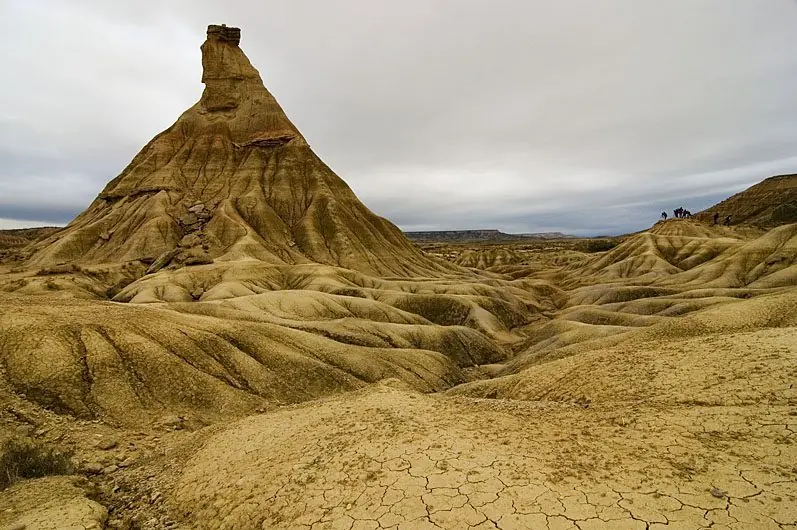
We are in the southeast of Navarre, in a semi-desert of clays and gypsum of some forty-two thousand hectares, eroded until it looks like another planet. It has been a Natural Park since 1999 and a Biosphere Reserve since 2000. And inside that protected perimeter, since the early 1950s, there has been an aerial firing range of the Spanish Air Force (Ejército del Aire), also used by allied forces.
I am not here to prove anything. I am here to sort through the smoke so you can see where the flame comes from. And this is one of the few case files here at Broken UFO where the restricted zone does not have to be deduced: it is published, it has coordinates, it has a schedule and it has an administrative file. Which, curiously, has not stopped it from being blamed for everything.
What can be verified, first: who owns this
First of all, ownership, because it is the strangest and most beautiful part of the case file. The Bardenas belong neither to the State nor to the foral community: they are held for communal use by some twenty congozante entities (towns of the river valley and the middle zone, two Pyrenean valleys and a monastery) whose rights date from the Middle Ages and have been maintained, with their lawsuits and their ordinances, to this day.
That means that every September, when the flocks come down from the northern valleys to winter in the Bardena, a grazing right centuries old is being exercised. It also means that the military installation was established through an agreement with that owner community, in exchange for compensation, rather than simply set up on public land, and that agreement has been renewed periodically amid considerable argument.
That is the second verifiable fact, which is political and has been running for decades. The existence of the range has generated organized social opposition in Navarre, with annual demonstrations, actions to enter the site, court proceedings and statements from the Parliament of Navarre itself calling for its closure. It is a public conflict, documented in parliamentary records and in the press, over whether a firing range fits inside a biosphere reserve, and no forum rumor.
And the third: the airspace over the zone is restricted, and that restriction appears in the Spanish aeronautical information publication, with its coordinates, its vertical limits and its activation conditions. Anyone can consult it. Far from a secret, it is an annex.
What you see from outside
An active aerial firing range produces, at night and in the early morning, a visual repertoire that is disconcerting in a depopulated district. Illumination flares that hang in the sky for a full minute and descend slowly. Countermeasure flares, which leave an aircraft in a burst and go out one after another. Tracers. Flashes on the ground. And aircraft flying very low, with navigation lights off or reduced, which are heard only after they have passed.
To that you have to add the geography. From many points along the Navarrese and Aragonese river valley you see an enormous, clean horizon, with almost no light pollution. An observer thirty kilometers away has no reference for judging size or distance: he sees a luminous object that stops in the air, changes intensity and disappears. It is the canonical description of a sighting, and it is produced by a scheduled exercise.
It is worth saying plainly, because it is not a slight against the witnesses but the opposite: the people who report this are seeing something real and describing it honestly. What is missing is not credibility. What is missing is the fact that there was an exercise that night.
The grazing right
The communal uses are consolidated that today sustain the community of congozante entities that owns the territory.
The range arrives
The aerial firing range is established through an agreement with the owner community, in exchange for financial compensation.
The opposition
A sustained social movement is organized against the installation, with annual demonstrations, lawsuits and parliamentary statements calling for closure.
Natural Park
The Bardenas as a whole is declared a Natural Park.
Biosphere Reserve
UNESCO adds the territory to the world network of biosphere reserves, with the range inside it.
Why this is not a Spanish Area 51
Because it is published
The essential difference from the Nevada site lies in legal regime rather than in size or importance. In Spain, a restricted airspace zone is established by an administrative act that has to be published, and its description goes into the aeronautical information publication precisely so that civilian pilots know where not to fly. An airport cannot have secret zones: it would be dangerous.
Because there are owners who ask questions
And because the land has owners with rights and with lawyers. A community of congozante entities that has spent centuries defending its pastures in court is not a comfortable neighbor for an opaque installation. Every renewal of the agreement has involved negotiation, figures and publicity. It is hard to imagine a model of secrecy that survives that.
What can be criticized
None of the above means the matter is well settled. That a firing range operates inside a biosphere reserve is a contradiction that the Parliament of Navarre itself has pointed out, and the debate over environmental impact, noise and unexploded ordnance is legitimate and open. This case file does not defend the range: it argues that its discussion is public and that nothing is hidden there.
Why this case does not die
Because there is no way for a resident of the river valley to know, at three in the morning, whether there is an exercise that night. Activations are published through aeronautical channels, which is where they have to be, and not through the channels by which the people who live underneath find things out. The result is a permanent gap between information that is public and a population that does not receive it.
And because the landscape helps. The Bardenas are, visually, the most Martian place on the Iberian Peninsula: gullies, knolls, a clay cone that looks like a sculpture and kilometers without a streetlight. Shooting a science fiction film there is so easy that it has been done several times. Any story is forgiven in terrain like that.
The practical lesson is the usual one here at Broken UFO, and it applies to all of Spain: before treating a sighting as anomalous in a district with a military installation, you have to go and check whether the airspace was activated. That fact exists, is public and is almost never consulted. It is explained in the case file on how restricted airspace is declared in Spain.
The calendar rules, here too
There is one detail that seems to me the most telling in the case file and that is almost never told, because it requires knowing the terrain and not just the map: in the Bardenas two calendars coexist that ignore each other.
The first is the age-old one. In mid-September, around the Sanmiguelada, the flocks come down from the Pyrenean valleys to winter in the Bardena, and they stay there until spring. It is a movement of tens of thousands of head, with shepherds, with stone corrals built generations ago and with a regime of use that has been set down in writing for centuries. It is a working livestock operation inside the same perimeter, and no folklore.
The second is that of the exercises, which is planned on operational criteria and communicated through aeronautical channels. The two calendars cross over the same ground and practically do not speak to each other. The shepherd does not consult the notices to air navigators, and the planner does not consult the grazing ordinances.
Two things come out of that mismatch. The first is the environmental and social conflict that has been open for decades and that is the serious part of the matter: ordnance, noise, access restrictions and a perfectly legitimate discussion about what fits inside a biosphere reserve.
And the second, the one that concerns us: an entire district that sees things in the sky and has no channel through which to find out what they were. The sighting reports from the Navarrese river valley and the lower Aragon do not come from gullible people. They come from people who work outdoors at night, who know their sky far better than any city dweller, and who see exactly what they say they see. What they lack is the fact of what was scheduled.
And there is a reasonable proposal that this archive endorses: publish the zone’s activation in a format that reaches the congozante town councils, and not only the aeronautical information. It would cost nothing, it compromises no operation and it would resolve at a stroke a considerable part of the casuistry of an entire district.
The liability left in the ground
And there remains a matter that is little discussed and that is, in my judgment, the most serious of all: what a firing range leaves buried.
On any range of this kind, a fraction of the munitions used does not detonate as it should. Practice bombs, rockets, projectiles: some stay in the terrain, sometimes on the surface and sometimes buried by the impact itself and by decades of clay washing down. It is a known problem, documented on every firing range in the world, and it requires keeping specific areas fenced off even when there is no activity.
That has two practical consequences worth keeping in mind. The first is safety: there are areas of the site where one cannot move freely even though the rest is a Natural Park and open to the public. The second, and it is the one that will weigh the day something is decided, is that removing unexploded ordnance from land used for seventy years is a long, expensive and technically delicate operation, not a formality.
That is why the discussion about closure is not settled with a signature. Whoever demands the return of the land also demands, whether they want to or not, a cleanup that someone will have to pay for and that will take years. It is exactly the kind of administrative fact that does not fit on a placard and without which one cannot understand why a conflict has gone forty years without resolution.
A semi-desert that has belonged to a group of towns since the Middle Ages, protected by UNESCO, with a firing range inside it and the sheep coming down every September by the same old road. All of that at once, and in writing. In Spain the secret is almost never hidden: it is published in a bulletin that nobody reads.
OSINT – Source traceability
The exact area of the range and the amount of compensation under the agreement are not reproduced: different figures circulate and they do not come from a single consultable document. The number of congozante entities is given approximately for the same reason. The dates of the Natural Park and Biosphere Reserve declarations are well established.