
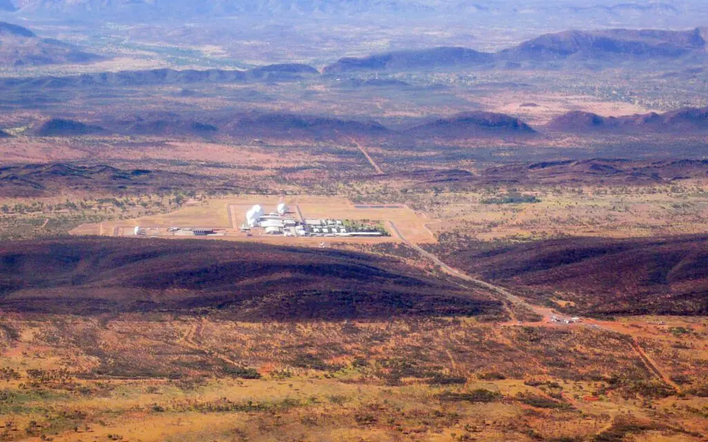
Pine Gap: Why the Golf Balls Sit at the Exact Center of Australia
It isn't there because of what lies beneath it. It's there because the sea is a thousand kilometers away and nobody can position themselves inside the footprint of the signal.
The Joint Defence Facility Pine Gap, in operation since 1970 under a 1966 intergovernmental agreement, is a joint Australian-U.S. control and receiving station for signals intelligence satellites. Its location in the middle of the continent answers a technical reason: preventing any outside ship or installation from positioning itself inside the footprint of the downlink transmission. Its existence and legal regime are public; its secret is the operational detail. The attributions of non-human activity or extraordinary underground facilities lack any documentary basis.
Executive summary of the case file. Everything essential before you dig deeper.
Fact sheet
OSINT - Traceability
Friends, today we go to the exact center of Australia, one of the few places on the planet where geography can be read like a classified document. About twenty kilometers from Alice Springs, in the middle of a continent, there is a valley with some thirty white domes that look like giant golf balls. It is called Pine Gap. And the question to ask is why it is exactly there, before what it hides.
I stick to my own ground: papers, dates, agencies. And this place has all of those, to a surprising degree. There is a treaty signed between two governments, there are parliamentary debates, there are trials, there is peer-reviewed academic literature, and there is even a series of analyses published by civilian researchers who set about counting antennas on commercial satellite imagery. Pine Gap is a reasonably well-documented secret facility, which is a category that exists and that we almost never notice.
The curious thing is that its real function, the one on the record, matters infinitely more to the life of any one of us than the one mythology assigns to it. And yet the other one is the one that circulates.
What can be verified, first: why the middle of the desert
Let’s start with the geographic question, because its answer is the key to the whole case file and it is wonderfully concrete. A ground station that receives data from satellites in geostationary orbit has a very specific security problem: the satellite transmits downward, and that transmission, however directed it may be, spills over a wide area of terrain. Anyone inside that footprint can try to pick it up.
The solution is elementary: put the station so far from any coast, border or international waters that no ship, no submarine and no embassy can position itself inside the footprint. The center of Australia is, for that purpose, one of the best locations on the planet. It is more than a thousand kilometers from the sea in every direction, and there is no neighboring country that might think of parking a fishing boat.
That is the reasoning that appears in the literature on the facility, and it explains, with no further mystery, the choice of an empty valley. Pine Gap is where it is because of trigonometry and the law of the sea, not because of what lies underneath.
The second verifiable point is what it does. The facility controls and receives data from signals intelligence satellites in geostationary orbit over Asia: craft that listen to missile-test telemetry, communications and radar emissions across an enormous swath of the world. Over time an early-warning function was added: processing the signal from satellites that detect the flash of a launch.
And the third, what makes this a case file and not an encyclopedia entry: none of it became known through a press release. It became known through accidents. The first generation of those satellites came to light in the late 1970s in the wake of an espionage case in the United States, when an employee of the contractor company sold documentation on the program. A court, court records, code names. That is how the world found out what the golf balls were for.
The political episode that still hurts
In November 1975 the governor-general of Australia dismissed Prime Minister Gough Whitlam in the gravest constitutional crisis in the country’s history. Whitlam had been asking uncomfortable questions about the joint facilities and about the role of the U.S. services in them, and the Pine Gap agreement was close to renewal.
Here we have to slow down and say exactly what is known and what is not. That Whitlam was pressing the issue is documented. That the lease was expiring around then is also documented. That there was a causal relationship between the two is a hypothesis that has been debated for fifty years and that no one has proved. Here at Broken UFO we record it for what it is: a real political controversy with no conclusive document behind it, not a fact.
What does remain of all that, and it is a lot, is an uncomfortable institutional finding: a sovereign country discovered that it hosted a facility whose operation it did not fully control and about which its own parliament had difficulty obtaining information. That is the Australian debate over Pine Gap. It lasts to this day and it does not need a single extraterrestrial to be unsettling.
The agreement
Australia and the United States sign the agreement that will give rise to the facility, initially presented as a space research center for defense.
In operation
The station begins operating in a valley southwest of Alice Springs.
The crisis
The governor-general dismisses the Australian prime minister amid controversy over the joint facilities. The causal link is debated; it has not been proved.
The secret breaks
An espionage case in the United States brings to light the first generation of signals intelligence satellites whose control was at Pine Gap.
Academia steps in
Serious university research begins to be published on the facility, its function and its implications for Australian sovereignty.
The leaked documents
Material declassified through a leak names the facility again within global interception programs.
Why it is credited with what it is credited with
The radomes
The white domes are, probably, the best generator of architectural mythology of the twentieth century. Their function is twofold and perfectly prosaic: to protect the antennas from wind, sand and temperature, and (this is the important part) to prevent anyone from seeing where they point. An uncovered dish gives away its target just by being looked at. A dome turns extremely valuable information into a smooth surface.
The closed airspace
Overflight is prohibited above the facility, and that is another classic. Restricted airspace automatically produces two effects: it prevents photography from above and it suggests there is something that deserves not to be photographed. Both things are true. What must not be photographed is the layout of the antennas, which reveals what is being listened to.
The subsurface
And the star claim, the one about underground levels. Precision matters here: there is buried construction, as in any facility of this kind, because processing equipment and control rooms are protected. What there is not is a single indication of anything more. A deep excavation leaves spoil heaps, traffic, electricity consumption and contracts, and the facility has been photographed for half a century by commercial satellites that anyone can hire.
Why this case won’t die
Because the secrecy is real and the facility affects people’s lives. This is a place about which a national parliament has had real difficulty obtaining information, and whose activity has been involved in operational decisions with consequences outside Australia. When a citizen senses that something is going on in there that they are not being told, they are right. They are only wrong about the content.
And it won’t die because the real explanation requires understanding what a geostationary orbit is, what a transmission footprint is and why a radome covers an intention. That is three paragraphs of physics and law. “Underground alien base” is three words. All else being equal, the three words win.
There is also a contamination effect worth pointing out. Every time mythology appropriates a place like this, it does an enormous favor to whoever runs it: it turns any legitimate question about its activity (what is intercepted, with what safeguards, under what judicial control) into a conversation about saucers. The fantastical conspiracy is, often, the best friend of the real secret.
It is the same thing that happens with the Nevada site, and for the same reason: closed places, with a known and boring content, wrapped in an invented and thrilling one. Anyone who wants to know what is hidden in a facility like this has to read a treaty and a budget, not a forum.
How to investigate a facility like this from the outside
And now what I want to tell you, because it transfers to any closed site in the world. You don’t get into Pine Gap. And yet quite a lot is known about it, and what is known was not leaked by anyone from inside: it has been reconstructed from outside, with methods within reach of anyone with patience.
The first method is commercial imagery. For more than two decades anyone has been able to buy sub-meter resolution satellite photographs of any point on the planet. Australian researchers have used time series of those images to count antennas, measure the diameter of each radome, date when each one appeared and follow the growth of the processing buildings. From that comes a capacity estimate that no press release has ever given.
The second is peripheral administrative paperwork, which is where the good material always is. A facility of this size contracts civil works, consumes electricity, applies for permits, generates waste, rents housing for its staff and publishes job offers with very specific technical profiles. None of that is classified, and all of it together draws a fairly precise silhouette of what goes on inside.
The third is the parliamentary record. In a democratic system, even a secret facility generates questions, answers, appearances and budget lines. Reading fifty years of those answers in sequence (including the ones that don’t answer) says a great deal, because changes in wording mark changes in function.
And the fourth is the judicial route. When someone enters the site and is prosecuted, the proceedings generate public documentation: which rules apply, what counts as a prohibited area, what is protected. The trials of activists have ended up, paradoxically, as one of the most precise sources on the legal regime of the place.
That is the work. No anonymous sources, no distorted voices: images that are bought, files that are requested and sessions that are read. Extremely boring and considerably more productive than any interview with a supposed informant.
The footprint, in round numbers
To understand why geography rules so much here, it helps to put numbers on it. A satellite in geostationary orbit is about thirty-six thousand kilometers up, the distance at which one trip around the Earth takes exactly one day and it therefore appears motionless above a point on the equator. From there, any antenna transmitting downward illuminates an enormous surface by sheer geometry: even if the beam is very narrow in angle, at that distance the circle it draws on the ground is measured in hundreds of kilometers.
That means the downlink signal of a spy satellite does not reach only its station: it reaches everything inside that circle. Anyone inside it with a dish of the right size can try to pick up the same transmission the official station receives. They will not be able to decrypt it, but they will be able to analyze when it transmits, how much traffic it carries and where the satellite is pointing, which is extremely valuable information.
Hence the choice of central Australia, and hence the same logic explains where the other stations of this type around the world are. Remote sites are not sought for visual discretion (a facility like this cannot be disguised) but for a purely physical reason: you have to guarantee that nobody can legally position themselves inside the circle.
It is a perfect example of something this archive repeats often: when a decision seems mysterious, there is usually a technical constraint behind it that explains it with no margin left over. Here the constraint is trigonometry, and the sea is too far away.
Thirty white domes in a red valley, put there because the sea is too far away for anyone to listen in. Of all the reasons a place can be secret, that is the most elegant and the one least told.
OSINT – Source traceability
The relationship between the 1975 Australian constitutional crisis and the facility is expressly presented as a debated, unproved hypothesis. Program code names and the exact number of antennas are not reproduced: they vary between sources and between periods.